- Acanthophoenix
- Acrocomia
- Actinokentia
- Actinorhytis
- Adonidia
- Aiphanes
- Allagoptera
- Ammandra
- Aphandra
- Archontophoenix
- Areca
- Arenga
- Asterogyne
- Astrocaryum
- Attalea
- Balaka
- Barcella
- Basselinia
- Beccariophoenix
- Bismarckia
- Borassodendron
- Borassus
- Brassiophoenix
- Burretiokentia
- Butia
- Calamus
- Calyptrocalyx
- Calyptrogyne
- Calyptronoma
- Carpentaria
- Carpoxylon
- Caryota
- Ceratolobus
- Ceroxylon
- Chamaedorea
- Chamaerops
- Chambeyronia
- Chelyocarpus
- Chuniophoenix
- Clinosperma
- Coccothrinax
- Cocos
- Corypha
- Cryosophila
- Cyphokentia
- Cyphophoenix
- Cyphosperma
- Daemonorops
- Deckenia
- Desmoncus
- Dictyocaryum
- Drymophloeus
- Dypsis
- Elaeis
- Eleiodoxa
- Eremospatha
- Eugeissona
- Euterpe
- Gaussia
- Geonoma
- Guihaia
- Hedyscepe
- Hemithrinax
- Howea
- Hyophorbe
- Hyospathe
- Hyphaene
- Iriartea
- Iriartella
- Itaya
- Jailoloa
- Johannesteijsmannia
- Juania
- Jubaea
- Jubaeopsis
- Kentiopsis
- Kerriodoxa
- Korthalsia
- Laccospadix
- Laccosperma
- Lanonia
- Latania
- Lemurophoenix
- Leopoldinia
- Lepidocaryum
- Lepidorrhachis
- Leucothrinax
- Licuala
- Linospadix
- Livistona
- Lodoicea
- Lytocaryum
- Manicaria
- Manjekia
- Marojejya
- Masoala
- Mauritia
- Mauritiella
- Maxburretia
- Medemia
- Metroxylon
- Myrialepis
- Nannorrhops
- Nenga
- Neonicholsonia
- Neoveitchia
- Nephrosperma
- Normanbya
- Nypa
- Oenocarpus
- Oncocalamus
- Oncosperma
- Orania
- Oraniopsis
- Parajubaea
- Pelagodoxa
- Phoenicophorium
- Phoenix
- Pholidocarpus
- Pholidostachys
- Physokentia
- Phytelephas
- Pigafetta
- Pinanga
- Plectocomia
- Plectocomiopsis
- Podococcus
- Pogonotium
- Ponapea
- Prestoea
- Pseudophoenix
- Ptychococcus
- Ptychosperma
- Raphia
- Ravenea
- Reinhardtia
- Retispatha
- Rhapidophyllum
- Rhapis
- Rhopalostylis
- Roscheria
- Roystonea
- Sabal
- Sabinaria
- Salacca
- Saribus
- Satakentia
- Satranala
- Schippia
- Sclerosperma
- Socratea
- Solfia
- Sommieria
- Syagrus
- Synechanthus
- Tahina
- Tectiphiala
- Thrinax
- Trachycarpus
- Trithrinax
- Veitchia
- Verschaffeltia
- Voanioala
- Wallaceodoxa
- Wallichia
- Welfia
- Wendlandiella
- Wettinia
- Wodyetia
- Zombia
- x Jubautia splendens
- ?? Acoelorrhaphe
- ?? Bentinckia
- ?? Brahea
- ?? Clinostigma
- ?? Colpothrinax
- ?? Copernicia
- ?? Cyrtostachys
- ?? Dictyosperma
- ?? Dransfieldia
- ?? Heterospathe
- ?? Hydriastele
- ?? Iguanura
- ?? Incertae sedis & excluded names
- ?? Loxococcus
- ?? Micronoma
- ?? Paripon
- ?? Pritchardia
- ?? Rhopaloblaste
- ?? Serenoa
- ?? Washingtonia
Main menu

Distribution
Map uses TDWG level 3 distributions (https://github.com/tdwg/wgsrpd)
Throughout the Amazon region, in tropical moist and wet forest on terra firme. (Borchsenius F., Borgtoft-Pedersen H. and Baslev H. 1998. Manual to the Palms of Ecuador. AAU Reports 37. Department of Systematic Botany, University of Aarhus, Denmark in collaboration with Pontificia Universidad Catalica del Ecuador)A
Common and widespread throughout the Amazon region and adjacent areas in Colombia (Amazonas, Córdoba, Guainía, Vaupés), Venezuela (Amazonas, Bolívar), Trinidad and Tobago, the Guianas, Ecuador (Napo, Sucumbíos), Peru (Cusco, Huánuco, Loreto, Madre de Dios, Pasco, San Martfn, Ucayali), Brazil (Acre, Amapá, Amazonas, Maranhão, Pará, Rondônia, Roraima), and Bolivia (Beni , La Paz, Pando); lowland forest on terra firme, but also in open, sandy areas at both low and high (10-1800) m elevations. (Henderson, A.J., Bactris (Palmae) in Flora Neotropica Monographs 79. 2000)B
Discussion
- A widespread, variable species that includes several morphological forms joined by intermediate populations. (Borchsenius F., Borgtoft-Pedersen H. and Baslev H. 1998. Manual to the Palms of Ecuador. AAU Reports 37. Department of Systematic Botany, University of Aarhus, Denmark in collaboration with Pontificia Universidad Catalica del Ecuador)A
- Bactris simplicifrons is diagnosed by its 1-2(-3) rachillae 3-6 cm long, pistillate flowers with equal calyx and corolla, and globose, orange or red fruits 5-8 mm diameter. Synonymy was established by Wessel Boer (1965, 1988) and Henderson (1995). Wessels Boer (1988) kept B. ulei separate from B. simplicifrons, based on the pubescence of the abaxial leaf surface. The blade of the type of B. ulei is sparsely and minutely spinulose abaxially, whereas Wessels Boer 2383 is pilose abaxially. Otherwise, both specimens are typical B. simplicifrons.
This is one of the most common, widespread and variable species of Bactris. It is also frequently collected, so that it is possible to get some idea of the variation of leaf shape, degree of spininess, and inflorescence size over its range.
In the Guianas, there is a widespread form occurring in lowland rain forest on terra firme. Plants are usually without spines (except for spinules on the leaf apex), and the blade is simple with sigmoid venation. The lobes of the blade are typically 17-26 cm long and 4-10 cm wide. A larger-leafed form also occurs here, with the blade simple and sigmoid venation, and the lobes 24-58 cm long and 9-10 cm wide. Equally often, pinnate-leafed plants occur with 2-6, sigmoid pinnae per side, the pinnae 11-27 cm long and 1.5-7 cm wide. Independent of leaf shape, the rachillae are either to 6 cm long with larger fruits, or to 3 cm long with smaller fruits. A few plants from white-sand savanna regions are spiny, with the sheath and proximal part of the petiole covered with few to many, flattened, black spines to 1(-1.5) cm long .
In the Guayana Highland region of Venezuela, and adjacent parts of Brazil and Colombia, the majority of specimens are spiny. These are found on white-sand soils and podzols in poorly-drained places, usually in black-water areas, in forest, campina, or savanna at both low and high (to 1700 m) elevations. Individual specimens have been referred to as B. acanthocnemis and B. tenuis. This form also occurs sporadically on white-sand formations near Manaus, and south of the Amazon river near Humaita, Borba, and the upper Rio Tapajos. Leaves of these spiny plants are mostly pinnate with sigmoid pinnae. Some plants have simple, oblanceolate, deeply bifid leaves, with linear, strongly plicate lobes 27-44 cm long and 1.5-5 cm wide. Plants with this leaf shape have been called Bactris huberiana and B. luetzelburgii.
In the central Amazon region of Brazil most plants have simple leaves, with lobes typically 17- 26 cm long and 4-10 cm wide. Pinnate-leafed plants occur near Tere, and occasionally in other places.
In the western Amazon region of western Brazil , Colombia, Peru, and Bolivia there is considerable variation. Typical forms occur, but there are also some unusual ones. Some plants from Peru (Loreto) and Brazil (western Amazonas) have small, simple leaves with the lobes 13-17 cm long and 1.5-3 cm wide. Most specimens from Pasco, Peru, have numerous, sigmoid pinnae. Some specimens from Peru appear intermediate between B. simplicifrons and B. killipii or B. schultesii (e.g., Knapp & Mallet 6510, Knapp & Mallet 7146). One specimen (Colombia. Amazonas: Araracuara, rd. to Puerto Arturo, 360 m, 19 Sep 1987, Galeano & Huiloto 1286 (COL, NY)) has pinnate leaves with densely spinulose rachises, as in B. hirta, with inflorescences of B. simplicifrons. (Henderson, A.J., Bactris (Palmae) in Flora Neotropica Monographs 79. 2000)B
Common Name
- Brazil: maraja, ubim-mirim. Colombia: chontaduro de rana de rastrajo. jo-da-jime-ru (Huitoto), oo-ree-ñaw (Barasana). u-ma-chú-ku-su (Kofan). Guyana; parapi-balli. Peru; ceyacepan (Ameshua), chontilla, kamanchá (Mayna Jívaro), mashipongo, pijuaito, rotetenpar (Ameshua). Suriname: kiskismaka, yuyba. Venezuela; corocillo, cubarillo, San Pablo. (Henderson, A.J., Bactris (Palmae) in Flora Neotropica Monographs 79. 2000)B
Description
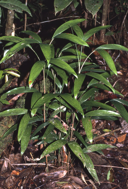
- Understorey palm. Stems solitary or clustered, to 1.5 m tall, only 5-6 mm in diameter. Plants spineless except for minute bristles along the outer leaf margin. Leaf blade 15-40 cm long, simple and then with rachis less than 10 cm long, or more or less regularly divided, with up to 7 sigmoid pinnae on each side, these inserted in one plane, the central ones to 16 cm long, 2.5-3.0 cm wide. Inflorescence unbranched, 4-8 cm long, with glabrous peduncular bract. Female flowers scattered along the branches, with a tubular calyx enclosing the corolla. Fruit 5-10 mm in diameter, yellow to red, glabrous; fruiting perianth with a 3-lobed calyx as long as the 3-lobed corolla; staminodial ring absent. (Borchsenius F., Borgtoft-Pedersen H. and Baslev H. 1998. Manual to the Palms of Ecuador. AAU Reports 37. Department of Systematic Botany, University of Aarhus, Denmark in collaboration with Pontificia Universidad Catalica del Ecuador)A
- Stems solitary or cespitose, 0.5-2 m tall, 0.3-1 cm diam., erect or leaning, not spiny on internodes. Leaves 5-9; leaf spines absent except for apex of pinnae, or spines scattered, black, flattened, to 1.5 cm long, few to moderate on sheath and petiole; sheath 5-20 cm long, closed but not forming a crownshaft; ocrea to 2 cm long; petiole 5-26 cm long; rachis 8-25 cm long; blade typically simple and shaped like a whale's tail fin , the lobes 24-58 cm long, 1.5-15 cm wide, or oblanceolate, plicate, deeply bifid apically and cuneate basally, or leaf pinnate, the pinnae 2-6(-20) per side, irregularly or regularly arranged, linear, linear-lanceolate or sigmoid, glabrous except for a few, small spines distally on margins, rarely sparsely and minutely spinulose or pilose abaxially; middle pinnae 10-33 x 1.5-15 cm.
Inflorescences interfoliar but appearing infrafoliar because exserted through leaf sheath; peduncle 3-4 cm long, strongly recurved in fruit, not spiny; prophyll 3-7 cm long; peduncular bract 6-12 cm long, usually not spiny, glabrous, whitish or brownish tomentose, erect at anthesis and forming an angle of ca. 30° with stem; rachis 0-0.5 cm long; rachillae 1-2(-3), 3-6 cm long, at anthes is pendulous, densely whitish brown-tomentose or almost glabrous; triads regularly arranged almost throughout rachilla(e); staminate flowers 3.5-4.5 mm long, deciduous; sepal lobes 1-1.5 mm long; petals 3-5 mm long; stamens 6; pistillode absent; pistillate flowers 2.5-5.5 mm long; calyx tubular, 2.5-5 mm long; corolla tubular, 2.5-5.5 mm long; staminodes absent; fruits 5-8 mm diam., globose, rostrate, orange or red; mesocarp starchy; endocarp obovoid, longitudinally grooved, the pores equally spaced; endocarp fibers few or absent; fruiting perianth with deeply 3-lobed calyx as long as the deeply 3-lobed corolla, without staminodial ring. (Henderson, A.J., Bactris (Palmae) in Flora Neotropica Monographs 79. 2000)B
Materials Examined
- COLOMBIA. AMAZONAS: Río Cahuinarí. near Quebrada de la Yuma, 230 mt 7 Sep 1987, Galeano & Miraña 1611 (COL, NY); La Pedrera., Río Caquetá, Cerro Yupati, 300 m, 8 Mar 1990, Galeano et al. 1975 (BH, FTG, K, NY), Apr 1944, Schultes 5854 (BH, GH); Parque Nacional Natural Amacayacu, 3°2'N, 70°W, 22 Jun 1991 , Rudas et al. 2335 (MO), 24 Jun 1991 , Rudas et al. 2408 (MO), 1 Jul 1991 , Rudas et al. 2703 (MO), 27 Sep 1991, Rudas & Prieto 3186 (MO).
CÓRDOBA: Tierralta between Río Esmeralda and Sinú, 200 m, 26 Jul 1986, Bernal et al. 1163 (B, COL, FTG, NY).
GUAINÍA: Río Negro opposite San Carlos, 1°47'N, 67°6'W, 8 Apr 1984, Gentry & Stein 46441 (MO, US).
VAUPES: Amazonas-Vaupes border, Río Apaporis, 5 Jul 1951, Schultes & Cabrera 12931 (COL, BH, US); Soratama. Río Aapaporis between Río Pacoa and Kananari, 31 Aug 1951, Schultes & Cabrera 13801 (BH, COL, US); Río Apaporis, 0°15'S, 70°30'W, 8 Jun 1952, Schultes & Cabrera 16642 (BH), 8 Jun 1952, Schultes & Cabrera 16648(BH), 6 Sep 1952, Schultes & Cabrera 17211 (BH, COL, US) , 10 Sep 1952, Schultes & Cabrera 17341 (BH), 25 Sep 1952, Schultes & Cabrera 17614 (BH); 1°0'N, 70°15'W, s.d., Schulles & Cabrera 183350 (BH); Mitu, 25 Apr 1975, Zarucclli 1285 (BH, COL).
VENEZUELA. AMAZONAS: Dept. Atures, Puerto Ayacucho, between Saramasota and Salto Nieve, 6°25'N, 67°25'W, 90-100 m, 10 Aug 1986, Castillo 2055 (US); Santa Barbara del Orinoco, 22 May 1975, Berry 591 (BH); Dept. Atures, 26 km SE of Puerto Ayacucho, 5°31'N, 67°24'W, 80 m, 21-22 Feb 1989, Cuello & Fernández 477 (NY); Dept. Río Negro, Río Mawarinuma, 0°5'N, 66°5'W, 150-300 m, 8-15 Jul 1984, Davidse & Miller 27125 (NY), 24 Apr 1984 Gentry & Stein 46903 (MO), 14 Feb 1984, Henderson 24 (FTG, NY), 6 Mar 1984, Liesner & Funk 16439 (MO, NY), 5 Feb 1984, Luteyn 9392 (NY), 18 Apr 1984, Plowman & Thomas 13675 (F), 23 Apr 1984, Thomas 3232 (NY); San Fernando de Atabapo, 26 Mar 1974, Gentry et al. 10954 (MO); Dpto. Atures, Río Coro-Coro, W of Serranía de Yutaje, 5°38'N, 66°7'W, 200 m, 19 Feb 1987, Holst & Liesner 3082 (MO, NY); Dept. Atures, 30 Jan N of Puerto Ayacucho, Rincones de Chacorro, 5°48'N, 67°20'W, 80 m, 16 Jun 1981, O. Huber & Braun 6246 (US); San Carlos de Río Negro, 1°51'N, 67°3'W, 16 Nov 1977, Liesner 3562 (MO), 19 Nov 1977, Liesner 3684 (MO), 12 Apr 1979, Liesner 6544 (MO), 30 Apr 1979, Liesner7072 (MO), 21 Jan 1980, Liesner 8517 (BH, MO), 28 Jan 1980, Liesner 8791 (MO); Aracanumi, 1°24'N, 65°38'W, 600 m, 21 Oct 1987, Liesner & Delascio 22258 (MO, NY), 21 Oct 1987, Liesner & Carnevali 22283 (MO, NY, US); Cerro Marahuaca, 3°43'N, 65°30'W, 1200 m, 18 Oct 1988, Liesner 25031 (MO, NY), Liesner 25032 (MO); Piedra, 5°5'N, 67°19'W, 1050 m, Sep 1989, Sanoja et al. 3060 (NY); Río Casiquiare, Solano, 100 m, 8 Apr 1970, Steyermark & Bunting 102440 (BH, NY); Dept. Atures, 25- 35 km SE of Puerto Ayacucho, 5°27?N, 67°33'W, 80-100 m, 12 May 1980, Steyermark et al. 122329 (MO, NY); 45 km SE of Puerto Ayacucho, 5°35'N, 67°15'W, 100 m, 13 May 1980, Steyermark et al. 122392 (MO, NY); 70 km SSW of Ocamo, 2°10'N, 65°34'W, 24-28 Feb 1984, Steyermark et al. 130131 (MO); Cerro Marahuaca, 3°43'N, 65°31'W, 1140 m, 28 Feb- 1 Mar 1985, Steyermark & Holst 130877 (MO, NY); Dept. Atures. 25-35 km SE of Puerto Ayacucho, 5°27'N, 67°33'W, 80-100 m, 7 Sep 1985, Steyermark et al. 131532 (MO, NY), Steyermark 131533 (MO); near San Carlos de Río Negro, ca. 1°55'N, 67°W, ca. 125 m, 19 Jan 1968 , Wessels Boer 2283 (NY); near Santa Rosa de Amanodona, ea. 1°25'N, 66°50'W. ca. 120 m, 31 Jan 1968, Wessels Boer 2372 (NY); Río Negro, Piedra de Cucuy, ca. 1°13'N, 66°51'W, 100-350 m, 2 Feb 1968, Wessels Boer 2383 (NY).
BOLÍVAR: Isla del Río Hacha, 6°15'N, 62°47'W, 15 Feb 1964, Agostini 222 (BH); 7 km NW of La Clarita, 6°13'N, 61°27'W, 3 Aug 1985, Aymard et al. 3908 (MO); 62 km SE of La Paragua, 6°16'N, 63°18'W, 17 May 1987, Aymard 6124 (MO); Mun. Raul Leoni, 42.5 km SE of Entre Ríos, ca. 5°43'N, 64°7'W, 250 m 30 Oct-2 Nov 1988, Aymard & Fernández 7214 (NY); Río Apacara, region of Urimacau, 400-500 m, 20 Aug 1954, Bernardi 1496 (NY); Mun. Raul Leoni, 85 km from Uriman, 4°36'N, 62°44'W, 440 m, Sep 1986, Fernández 3470 (NY); Mun. Raul Leoni, 5°16'N, 63°59'W, 215 m, Nov 1988, Fernández & Aymard 4836 (NY); Guaiquinima, 5°51'N, 63°33'W, 900 m, 6 Dec 1987, O. Huber 12404 (NY); Rio Paragua between La Paragua and Salta de Auraima, 9 Apr 1943, Killip 37314 (BH, US); 20-25 k m SW of Monteco, 7°10'N, 62°55'W, 1-3 Aug 1978, Liesner & González 5972 (MO); Caño Pablo, tributary of Río Caura, 6°14'N, 64°23'W, 240 m, 10 May 1982, Liesner & Morillo 13986 (MO, NY); El Polo, 4°30'N, 61°40'W, 5 Nov 1985, Liesner 19596 (MO); Amaruay-tepui, 5°54'N, 62°15'W, 500 m, 22 Apr 1986, Liesner& Holst 20185 (MO); Gran Sahana, ca. 10 km SW of Karaurin Tepuí, 5°19'N, 61°3'W, 900-1000 m, 21 Apr 1988, Liesner 23526 (MO, NY); 5 km S of Sun Ignacio de Yuruaní, 4°59'N, 61°10'W, 9 May 1988, Liesner 24396 (MO); Cerro Guaiquinima, Río Paragua, 1600-1700 m, 10-12 Jan 1952, Maguire 33049a (NY); alto Río Cuyuni, Río Chicanan, Serra Uroi, 700 m, 12 Sep 1962, Maguire et al. 53740 (NY); Canaima, 6°16'N, 62°52'W, 2 Sep 1983, Prance & O. Huber 28496 (MO, NY); Gran Sabana, Maipatá, 4°53'N, 61°25'W, 830 m, 30 Apr 1991, Rosales & Dezzeo 837 (NY); Sacupana, Apr 1896, Rusby & Squires 410 (NY); Río Caura, 4°44'N, 64°1'W, 13-26 Apr 1988, Stergios 12053 (NY); Chimantá Massif, Río Apácapa, 415 m, 29 Mar 1953, Steyermark 74703 (NY); Sierra Imataca, between Río Reforma and rapids above Rio Reforma, 200-250 m, 14 Dec 1960, Steyermark 88054 (BH, NY), 14 Dec 1960, Steyermark 88063 (NY); Cerro Venamo, Río Venamo, 900-1000 m, 8 Jan 1964, Steyermark et al. 92837 (B , BH, NY); Cerro Guaiquinima, 5°44'N, 63°41'W, 750 m, 20-25 Jan 1977, Steyermark et al. 113323 (BH); near El Palmar, ca. 8°5'N, 61°50'W, ca. 75 m, 24 Nov 1967, Wessels Boer 2083 (NY).
TRINIDAD AND TOBAGO, TRINIDAD: Northern Range, Blanchisseuse Rd., Textel Station, 600 m, 15 Aug 1991, Henderson & Coelho 1620 (K, NY); Nariva, 10 Jan 1975, Kalloo B1128 (NY); Sangre Grande, 27 Jan 1927, Broadway 6538 (BM), 21 Oct 1927, B. Williams 11864 (K, NY)
GUYANA. Berbice-Rupununi Cattle trail, 1919, Abraham 107 (NY); Surama Village, 4°5'N, 59°4'W, 23 Feb 1990, Acevedo 3369 (CAY, NY, US); Cuyuni-Mazaruni Region, Essequibo River near Dennison Camp, 5°21'N, 58°48'W, 10-15 m, 27 May 1989, Gillespie & Persaud 1439 (NY), 9 Oct 1989, Gillespie & Tiwari 2225 (NY); Cuyuni Mazaruni Region Aurora, 6°47'N, 59°44'W, 60-75 m, 4 Oct 1989, Gillespie & Tiwari 2088 (NY); Demerara-Mahaica Region, along Soesdyke-Linden hwy., 6°25'N, 58°15'W, 10-30 m, 17 Feb 1988, Hahn et al. 3859 (NY); 8.6 km NE of Imbaimadai, 5°46'N, 60°15'W, 27 May 1992, Hoffman 1907 (NY, US) Cuyuni-Mazaruni Region, Pakaraima Mtns., Kurupung-Membaru trail, 6°5'N, 60°23'W, 22 Jul 1992, Hoffman & Marco 2132 (NY); Kuyuwini Landing, 2°10'N, 59°15'W, 200 m, 5 Feb 1991, Jansen-Jacobs 2385 (U); Rupununi Region, Ureisha Mtn., 4°10'N, 59°15'W, 5 Jan 1982, Knapp & Mallet 2850 (MO); Mazaruni River, Kamakusa, 9 Nov 1922, Leng 68 (NY); Mazaruni River, Kurupung, 21 Nov 1922, Leng 171 (NY); Matthews Ridge, Barima River, Northwest Territory, 22 Jan 1955. Maguire & R. Cowan 39294 (NY); Partang River, Merume Mtns., Imbaimadai Savanna, 488 m, 16 Jun 1960, Maguire et al. 43868 (NY); Cuyuni-Mazaruni Region, Paruima Village, 5°48'N, 61°3'W, 495 m, 19 May 1990, McDowell & Gopaul 2668 (NY, US); Kurupukari, 4°40'N, 58°40'W, 21 Sep, McDowell 3302 (NY); Potaro-Siparuni region, trail up Eagle Mtn., 5°12'N, 59°7'W, 8 Oct 1990, McDowell & Gopaul 3446 (NY); Old World, 7°22'N, 60°20'W, 6 Apr 1991, McDowell et al, 4258 (MO, NY, US); Mathews ridge, 7°26'N, 60°11'W, 28 Apr 1991, McDowell et al. 4482 (BM, CAY, NY, US); Potaro-Siparuni, 7 km S of Iwokrama, 4°35'N, 58°44'W, 8 Dec 1994, Mutchnick & Allicock 611 (NY); Mazaruni-Potaro Distr., Bartica-Potaro rd., 24 mi S of Bartica, 50-125 m, 15 Aug 1976, Mori et al. 8091 (NY); Cuyuni-Mazarun i Region, S of Mt. Ayanganna. 5°28'N, 60°4'W, 26 Feb 1987, Pipoly et al. 10674 (B, NY); Essequibo River, Twasinki Falls, ca. 5°5'N, 28 Sep 1937, A. Smith 2143 (F, MO, NY, US); upper Mazaruni River, Mt. Ayanganna, 700-800 m, 5, 16-17 Aug 1960, Tillett 45046 (NY); Upper Mazaruni River, Kako River, Karowtipu, 470 m, 19 Sep 1960, Tillett 45468 (NY); Kamarang River, 21 Oct 1960, Tillett 45725 (NY).
SURINAME. Nassau Mtns., Marowijne River, 400-550 m, 5 Jan 1955, Maguire et al. 39161 (NY), 10 Jan 1955, Maguire et al. 39205 (NY), 28 Feb 1955, Maguire et al 40722 (NY); Alalapadu, 8 Jul 1977, Moore et al. 10335 (BH); Cottica river on rd. from Paramaribo to Albina, 19 Jul 1977, Moore & Palmtak 10361 (BH); Piai Creek, 13 Sep 1920, Pulle 574 (NY); Albina, 23 Oct 1962, Wessels Boer 186 (NY); Zanderij, 13 Nov 1962, Wessels Boer 279 (NY); Coeroni Strip, 19 Jun 1963, Wessels Boer 1601 (NY).
FRENCH GUIANA. Haul Tampoc, Saut Pier Kourou, 7 Apr 1977, Cremers 4651 (CAY); Marouina, 11 Nov 1976, Cremers 5016 (CAY); Route Regina-Saint Georges, 4°3'N, 52°1'W, 7 Apr 1991, Cremers & Gautier 12037 (CAY); Mont Atachi Bacca. 3°33'N, 53°55'W, 12 Mar 1971, de Granville 164 (CAY), 12 Jan 1989, de Granville et al. 10622 (B, CAY, FTG, US), 22 Jan 1989, de Granville et al. 10884 (B, CAY, FTG, NY, US); Saul, 3°37'N, 53°12'W, 15 Dec 1970, de Granville 697 (CAY, NY), 21 Aug 1980, de Granville 3543 (BH, CAY, P), 26 Jul 1987, Hahn 3629 (CAY, US), 29 May 1986, Mori et al. 18164 (NY); Tumuc Humac, 3°37'N, 53°17'W, 30 Jul 1972, de Granville et al. 1031 (CAY), 26 Aug 1972, de Granville 1415 (CAY); Crique Roché Fendé, La Comté, 10 Feb 1973, de Granville 4714 (CAY); Fleuve Mana, 11 Aug 1981, de Granville 4816 (BR, CAY); Paul Isnard, 550 m, 14 Nov 1982, de Granville 5299 (BR, CAY); Montagnes de la Trinite, 3 Feb 1984, de Granville et al. 6461 (CAY); Haut Camopi, Mont Belvédère, 5 Dec 1984, de Granville et al. 7137 (CAY, P); Montagnes Bellevue de I'lnini, 15 Aug 1985, de Granville et al. 7498 (CAY); Mont Galbao, 3°37'N, 53°17'W, 8 Jan 1976, de Granville et al. 8470 (CAY), 9 Jan 1986, de Granville et al. 8512 (CAY); Crique Gabaret, 3°55'N, 51°48'W, 13 Apr 1988, de Granville et al. 10273 (CAY), 14 Apr 1988, de Granville et al.10297 (CAY); Inini, 3°33'N, 53°55'W, 20 Jan 1989, de Granville 10822 (B, CAY, FTG, NY, P, US); Gobaya Soula, 3°37'N, 53°58'W, 1 Feb 1989, de Granville et al. 10984 (CAY, FTG); Station de Nouragues, basin of l'Approuague, Arataye, 4°3'N, 52°42'W, 9 Aug 1989, de Granville et al. 11118 (CAY); Crique A1ama, Monts Tumuc Humac, 2°26'N, 54°25'W, 28 Jul 1993, de Granville 11861 (CAY, NY, US); Sinnamary, Saut Takari-Tante, 4°37'N, 52°56'W, 14 Nov 1989, Hoff 5811 (CAY); Sinnamary, Crique Kourcibo, 4°53'N, 53°3'W, 4 Apr 1990, Hoff et al. 6446 (CAY), Hoff et al. 6526 (CAY); Fleuve Maroni, 5 May 1975, Sastre 4168 (CAY, P); Crique Poivre, Mont Saint Marcel, basin of Haut Oyapock, 25 Mar 1976, Sastre 4539 (NY).
ECUADOR. NAPO: Mangu, 0°32'S, 76°23'W, 265 m, 19 Jun-14 Jul 1985, Balslev et al. 60514 (AAU).
SUCUMBÍOS: Reserva Cuyabeno, 0°2'S, 76°13'W, 18 Nov 1991, Palacios et al. 9117 (MO).
PERU, CUSCO: Patria, 13°7'S, 71° 12'W, 800 m, 4 Dec 1985, Wachler et al. 229 (NY, USM).
HUÁNUCO: Tingo María, 5 Oct 1972, Croat 21180 (BU, MO); Pachitea, Codo de Pozuzo, 9°37'S, 75°25'W, 500 m, 19 Oct 1982, R. Foster 9341b (MO, USM); E of Tingo María, Cerro Quemado, 700- 800 m, 7 Aug 1978, Schunke 10467 (MO).
LORETO: Caballo Cocha, 110 m, 23 Apr 1982, Ayala et al. 3299 (AMAZ); Quebrada Nawampa, 5 Jul 1975, Croal 17683 (MO); Río Nanay, 2 Aug 1972, Croat 18757 (BH,F,MO), 19 Feb 1969, Plowman 2516 (BH, US); Río Momón, 4 Sep 1972, Croat 20006 (BH, MO), 13 Sep 1995, Henderson & Padilla 2027 (NY); Prov. Maynas, Río Nanay, Caserio Mishana, 16 Aug 1978, C. Diazelaf. 418(MO), 19 Aug 1978, R. Foster 4218 (AMAZ), 16 Aug 1980, R. Foster 4338b (INPA , NY), 19 Mar 1982, Gentry et al. 36443 (MO), 31 Dec 1982, Gentry & Emtmons 38789 (MO); Jenaro Herrera. 4°55'S, 73°40'W, 22 Feb 1987, Gentry et al. 56354 (MO), 19 Mar 1985, Kahn & K. Mejia 178 f (CAY), Nov 1986, Kahn & K. Mejia 1978 (CAY), 21 Jan 1982, K. Mejia 40 (AMAZ); Prov. Alto Amazonas, 23 km SW of Yurimaguas, 5°59'S, 76°15'W, 200 m, 26 Feb 1988, Gentry et al. 61967 (MO, NY) ; Prov. Maynas, Indiana. 3°30'S, 73°3'W, 130 m, 14 Feb 1989, Gentry et al. 65782 (MO, NY); Maynas, km 21 on Iquitos-Nauta rd., Alpahuayo, 9 Sep 1995. Henderson & Padilla 2006 (NY); Prov. Maynas. Puerto Almendras, 3°48'S, 73°25'W, 122 m, 10 Sep 1995, Henderson & Padilla 2016 (NY), 20 Jul 1982, Vasquez & Jaramillo 3151 (MO), 29 Dec 1988, Vasquez & Jaramillo 11491 (MO, NY), 26 Oct 1989, Vasquez & Jaramillo 13029 (MO, NY); Maynas, km 16 on Iquitos-Nauta rd. , El Milagro. 15 Sep 1995, Henderson & Padilla 2031 (NY); Peña Blanca, Río Itaya, 110 m, 19 Sep 1929, Killip & A. Smilh 29659 (NY, US); Mishuyacu. Near Iquitos, 100 m, 24-28 Sep 1929, Killip & A. Smilh 29889 (F, NY, US); 27 km S of Yurimaguas, 5°59'S, 76°20'W, 13 Jun 1984, Knapp & Mallet 6510 (BH); Pampa Hermosa, 3°15'S, 75°50'W, 3-20 Dec 1985, Lewis et al. 10331 (MO); Maynas, Zangara Cocha, Río Itaya, 7 Oct 1968, McDaniel et al. 11243 (AMAZ); Sucusari , 3°20'S, 72°55'W, 28 Feb 1991, Pipoly et al. 13897 (MO), 6 Nov 1989, Vasquez & Jaramillo 13072 (MO); Santa Maria de Nanay, 3°55'S, 73°35'W, 130 m, 14 Mar 1991, Pipoly et al. 14916 (MO), 29 Feb 1968, Schunke 2438 (F, NY, US); Iquitos, Caserio Picuruyacu, 11 Feb 1976, Revilla 116 (MO); Maynas, Río Javari, 10 Sep 1976, Revilla 1323 (MO); Iquitos-Nauta rd., km 6, 8 Aug 1988, Rimachi 8714 (US); Punchana, Río Momón, 21 Jan 1993, Rimachi 10370 (NY); Brillo Nuevo, Río Yaguasyacu, 3°S, 73°5'W, 31 Oct 1981, Treacy & Alcorn 271 (F); Quebrada Ponaico, 4°30'S, 72°20'W, 18 Mar 1986, Vasquez & Jaramillo 7331 (MO); Río Nanay, 3°48'S, 73°25'W, 6 Mar 1987, Vasquez & Jaramillo 8933 (MO); Prov. Maynas, Iquitos, Moronillo, 3°45'S, 73°25'W, 18 Oct 1989, Vasquez & Jaramillo 12963 (MO, NY); Pinto Cocha, Río Nanay, Jun 1929. L. Williams 833 (F).
MADRE DE DIOS: Río Tambopala, jet. with Río La Torre, 12°50'S; 69°17?W, ca. 250 m, 16 Apr 1980, Barbour 4796 (MO), 15 Mar 1988, Bell et al. 88-182 (US), 6 Nov 1991. Henderson & Chavez 1639 (NY, USM), 20 Sep 1984, S. Smilh et al. 154 (US); Atalaya, 12°55'S, 71°12'W, 7 Dec 1983, R. Foster & Wachter 7262 (MO); Prov. Manu, Parque Nacional Manú, Río Manú, above Río Sotileja, 11°38'S, 71°54'W, 400-450 m, 11 Oct 1986, R. Foster et al. 11764 (F, NY).
PASCO: Oxapampa. Río Iscozacin, 10°20'S, 75°15'W, 320 m, 6 Jun 1983, Gentry et al. 41555 (AMAZ, MO); Oxapampa, Río Pichis, 10°10'S, 74°50'W, 17 Jun 1983, Gentry et al. 42133 (MO), 6 Sep 1982, R. Foster 8556 (MO); Oxapampa, Paleazú; Valley, Río Iscozacín, 10°12'S, 75°15'W, 10 Jan 1984, R. Foster et al. 7834 (MO, USM), 22 Jan 1984. R. Foster 7984 (MO), 13-19 Apr 1983, D. Smilh 3684 (MO), 2 Jul 1984, Solick 7169 (F, NY).
SAN MARTÍN: Near km 55 on Yurimaguas-Tarapoto rd., NE of Pongo de Canarachi. 6°15'S, 76°15'W, 230 m, 10 Oct 1985, Gentry et al. 52270 (MO, NY); km 68 Tarapoto-Yurimaguas rd ., Lamas, trail to Tioyacu and Nuevo Lamas, 6°16'S, 76°17'W, ca. 200 m, 19 Apr 1986, Knapp & Mallet 7114 (MO, NY, USM); Lamas, 6°16'S, 76°17'W, 20 Apr 1986, Knapp & Mallet 7146(MO); Tocache Nuevo, 8°14'S, 76°34'W, 550 m, 13 Dec 1981, Plowman et al. 11374 (F, NY), 14 Ju1 1974, Schunke 7397 (BH, F, MO), 17 Ju1 1974, Schunke 7502 (BH, NY), 23 Feb 1979, Schunke 10877 (MO).
UCAYALI: Between San Alejandro and Pucallpa, 6 Mar 1979, Schunke 10915 (MO).
BRAZIL. ACRE: Mun. Mancio Lima, Serra do Moa near Rio Moa, ca. 350 m, 12 Oct 1989, Henderson et al. 1120 (INPA, NY), 19 Apr 1971, Prance et al. 12109 (BH, INPA, NY); Rio Juruá-Mirim, Escuro, 8°7'S, 72°40'W, 9 Feb 1992, Henderson et al. 1667 (lNPA, NY); Río Moa, near jct. with Río Azul, Igarapé São Pedro, 7°18'S, 73°10'W, 15 Feb 1992, Henderson et al. 1695 (INPA, NY); Mun. Mancio Lima, ca. 5 km W of Mancio Lima, ca. 7°40'S, 72°55'W, 17 Feb 1992, Henderson et al. 1697 (INPA, NY).
AMAPA: Río Oiapoque, Igarapé Nataia, 5 Feb 1950, Fróes 25887 (BH).
AMAZONAS: Cacau Pirera-Manacapurú rd., km 5, 11 Sep 1975, A. Anderson 218 (BH); Mun. Itapiranga, Rio Uatumã, right bank opposite Igarape: Sta. Lucia, 17 Aug 1979, Cid et al. 462 (NY); Mun. São Paulo de Olivenca, 8 km S of main square, 3°30'S, 68°57'W, 5 Dec 1986, Daly et al. 4483 (NY); Ponte Negra, Manaus, 29 Jan 1963, Eiten et al. 5 183 (SP, US) ; km 130 on Manaus- Caracarai rd ., BR 174, 1 Dec 1974, Gentry 12967 (MO); BR 319 Porto Velho-Manaus, 85 km N of Humaitá, Bonfuturo, 7°10'S, 63°W, 7 Apr 1985, Henderson el at. 196 (INPA, NY); BR 319. Porto Velho-Manaus hwy., 20 km N of Humaitá, 7°30'S, 63°10'W, 9 Apr 1985, Henderson et al. 219 (INPA, NY); 60 krn N of Manaus on rd. to Caracarai, then 3 km Eon ZF 1, 4 Aug 1986, Henderson & Nascimento 641 (INPA, NY); Reserva Ducke, near Manaus on rd. to Itacoatiara, 10-21 Nov 1986, Henderson 663 (BH, INPA, NY), 24 Oct 1989, Henderson & Scariot 1171 (INPA, NY), 26 Oct 1989, Henderson & Scariot 1177 (INPA, NY), 23 Mar 1994, Ribeiro et al. 1242 (NY); Mun . Atalaia do Norte, Río Javari, Estirão do Ecuador, 4°33'S, 70°40'W, 8 Jan 1989, Henderson et al. 839 (COL, INPA, NY); Mun. Atalaia do Norte, Río Javari, Estirão do Ecuador, 4°33'S, 70°40'W, 8 Jan 1989, Henderson et al. 848 (NY); Mun. Atalaia do Norte, Río Javari , Estirão do Ecuador, 4°33'S, 70°40'W, 8 Jan 1989, Henderson et al. 857 (NY) 9 Jan 1989, Henderson et al 858 (COL, INPA , NY); Mun. Atalaia do Norte, Río Curuca, tributary of Río Javari, 4°30'S, 71°22'W, 12 Jan 1989, Henderson et al. 876 (lNPA, NY); BDFF Reserve km 41, 64 km N of Manaus on BR 174 and then 41 km E on ZF 3, 10 De 1989, Henderson et al. 1065 (INPA, NY) ; Mun. Maraá, Río Japura ca. 5 km W of Maraá, 11 Jan 1991, Henderson et al. 1537 (lNPA , NY); Mun. Alvaraes, Lago Tefé, opposite Tefé near Alvaraes, ca. 3°20'S, 64°50'W, 15 Jan 1991 , Henderson et al. 1551 (INPA, NY); Mun. Tefé, Río Parana do Irapajé, tributary of Río Tefé, 20 Jan 1991, Henderson & Guedes 1596 (INPA, NY); Borba, Río Madeira, 31 Dec 1990, Henderson & Pardini 1516 (NY); Río Negro, Cucuhy, 4-5 Feb 1930, Holt & Gehriger 349 (US); Mun. Humaita, between Río Livramento and Río ipixuna, 7-18 Nov 1934, Krukoff 7107 (MO, NY, US); vic. of Manaus, Cachoeira Baixa do Tarumã, 14 Mar 1967, Moore et al. 9526 (BH, INPA, NY); near Igarapé Leão, km 11 on Manaus-Caracarai rd., 17 Mar 1967. Moore et al. 9542 (BH, INPA , NY); Rio Cuieiras, 50 km upstream, 1 Apr 1974, Ongley & Ramos P2 1779 (INPA, NY); Mun. Tefé, Lago Tefé, NW shore, ca. 3°20'S , 64°50'W, 11-14 Dec 1982, Plowman 12610 (NY); Mun. Malaá, Rio Japurá, Sítio Fortaleza, ca. 7 km NW of Malaá, ca. 10°50'S, 65°38'W, 6 Dec 1982, Plowman et al. 12275 (INPA, NY); Manaus, Ponte Negra, 19 Dec 1962, Rodrigues & Coêlho 4931 (NY); Manaus, 15 Apr 1882, Schwacke 4057 (RB); Río Negro, IIha Tamanduá, 0°6'N, 67°16'W, 110 m, 18 Oct 1987, D. Stevenson et al. 731 (lNPA, NY); Río Negro, Cucui, 1°N, 66°48'N, 27 Oct 1987, D. Stevenson et al.832 (F, INPA, NY); Río Uaupes, Ipanore, Panure, 0°15'N, 68°39'W, 17 Nov 1987, D. Stevenson 938 (F, INPA, NY); Serra Aracá, 0°51'N, 63°22'N, 1150 m, 17 Feb 1984, Tavares et al.74 (K, NY), 15 Feb 1984, Amaral 1599 (NY); Tefé, 18 Dec 1876, Trail 915/XA (K); Rio Purus, 2 Oct 1874, Trail 918 (K); Río Javari, 4 Dec 1874, Trail 919/CLXXXI (K); Barcellos, 19 Jun 1874, Trail 920/LXIV (K); Calderao, Río Solimões, 10 Dec 1874, Trail 921 (K); Tonantins, 23 Nov 1874, Trail 922/CLXIX (K); Río Jutai, Barrieras Blancas, 3 Feb 1875, Trail 923/CLXIX (BM, K); Aremanahy, 10 Jan 1874, Trail 924N (K); Río Madeira below Exaltacion, 3 Jun 1874, Trail 925 (K); Villa Nova, 5 Apr 1874, Trail 927/XXXII (BM, K); Rio Purus, 30 Sep 1874, Trail 928 (K); Lago Juruty, 4 Apr 1874, Trail 929/XXVIII (K); Río Maues, 6 May 1874, Trail 930 (K); Manaus, 11 Feb 1875, Trail 931 (K); Barreiras de Janeiro, Río Jurua, 12 Nov 1874, Trail 932 (K); São Antonio da Boa Vista, 6 Dec 1874, Trail 933 (BM, K); Río Negro, Marapata, 30 Dec 1874, Trail 934 (K); Manaus, 12 Feb 1875, Trail 935 (K); Lages, mouth of Río Negro, 23 Jul 1874, Trail 936 (BM, K); 10 miles above Manaus, 7 Ju1 1874, Trail 938 (K); Río Paduari, 0°, 64°, 27 Jun 1874, Trail 939/LXXVIII (BM, K).
MARANHAO: Turiacu, km 6 on BR 106 Maracacumé-Sta. Helena, 30 Nov 1973, Rosa & Vilar 2773 (NY).
PARÁ: 5- 10 km downstream from Missão Cururú, 73°5'S, 57°31 'W, 120-150 m, 22 Feb 1974, W. Anderson 11109 (IAN, NY); Santarém-Cuiabá hwy., BR 163, km 1223 from Santarém, 18 Nov 1977, Balick et al. 934 (COL, K, NY); Santarém-Cuiabá hwy., BR 163, km 1417 from Santarém, Río ltapacura, 25 Nov 1977, Balick et al. 945 (NY); Faro, 10 Sep 1907, Ducke 8695 (RB, US); Serra de Ararauahy, Tapajos, 13 Apr 1924, Kuhlmann 1994 (RB); Mun. Tucuruí, 12 km N of Tucuruí on rd. to Cametá, ca. 3°36'S, 49°49'W, 50 m, 21 Mar 1980, Plowman et al. 9880 (FTG, NY); Mun. Anaja., IIha do Marajó, 2 km downstream from Bela Vista on Rio Mocões, 28 Oct 1984, Strudwick et al. 5002 (NY, US); Pará, 6 Mar 1875, Trail 916/X (BM, K), 4 Mar 1875, Trail 926 (K), 2 Mar 1874, Trail 937 (K); Porteira, Río Trombetas, 2 Mar 1874, Trail 917/XC (BM, K, NY).
RONDÔNIA: N bank of Rio Abuña, 10 km above Fortaleza, 17 Nov 1968, Prance et al. 8546 (BH, INPA, NY, US).
RORAIMA: Mun. Alto Alegre, IIha da Maracá, 3°22'N, 61°20'W, 17 Jul 1986, Henderson & Lima 153625 (INPA, NY); Serra Surucucus, 2°42'N, 63°33'W, 1800 m, 15 Feb 1969, Prance et al. 9968 (INPA , NY); vic. of Uaicá airstrip, Rio Uraricoeira, 3°33'N, 63°11'W, 8 Mar 1971, Prance et al. 10873 (BH, F, INPA, NY, US).
BOLIVIA. BENI: Prov. Vaca Diez, ca. 18 km E of Riberalta, 11°3'S, 65°50'W, ca. 230 m, 4 Sep 1981, Solomon 6120 (MO, NY).
LA PAZ: Prov. Iturralda, Ixiamas, San Antonio, 6 Aug 1990, O. Moreno 56 (NY); Prov. Abel Iturralda, Siete Cielos, Río Manúpare, 12°27'S, 67°37'37?W, 180 m, 4 Jun 1987, Solomon 16901 (NY), 8 Jun 1987, Solomon 16964 (MO).
PANDO: Lorna Alta, Río Madre de Dios, 10°47'5, 65°58'W, 20 Jun 1987, Solomon 17184 (MO); 9°52'S, 65°42'W, 14 Jul 1992, L. Vargas et al. 951 (LPB). (Henderson, A.J., Bactris (Palmae) in Flora Neotropica Monographs 79. 2000)B
Use Record
- Bactris simplicifrons Mart.: Bactris simplicifrons Mart. Español: Nejilla, Chondilla Usos: Medicinal y cosmético — Se utilizan los frutos contra la fiebre. Construcción — Ocasionalmente se usan las hojas en los techos de viviendas. Alimenticio — Ocasionalmente los frutos maduros son comestibles. Comunidad: 4, 7, 11, 12, 14, 19, 22, 25, 27. Voucher: H. Balslev 7100. (Balslev, H., C. Grandez, et al. 2008: Useful palms (Arecaceae) near Iquitos, Peruvian Amazon)
Use Category Use Sub Category Plant Part Human Group Ethnic Group Country Human Food Food Fruits Not identified N/A Peru Medicinal and Veterinary Not specified Fruits Not identified N/A Peru Construction Thatch Entire leaf Not identified N/A Peru Construction Thatch Entire leaf Not identified N/A Peru Medicinal and Veterinary Not specified Fruits Not identified N/A Peru Human Food Food Fruits Not identified N/A Peru - Bactris simplicifrons Mart.: Bactris simplicifrons Mart. Vernacular name: Boyegontiwe (adult). Voucher: Yanez, Macía et al. #2249. Use. D: Leaves are used for wrapping and packing materials. (Macía, M.J. 2004: Multiplicity in palm uses by the Huaorani of Amazonian Ecuador)
Use Category Use Sub Category Plant Part Human Group Ethnic Group Country Utensils and Tools Wrappers Entire leaf Indigenous Huaorani Ecuador Utensils and Tools Wrappers Entire leaf Indigenous Huaorani Ecuador - Bactris simplicifrons Mart.: Comestibles, para lavar ropa. (Albán, J. 1994: La mujer y las plantas útiles silvestres en la comunidad Cocama-Cocamilla de los ríos Samiria y Marañon.)
Use Category Use Sub Category Plant Part Human Group Ethnic Group Country Human Food Food Not specified Indigenous Cocama Peru Cultural Cosmetics Not specified Indigenous Cocama Peru Human Food Food Not specified Indigenous Cocama Peru Cultural Cosmetics Not specified Indigenous Cocama Peru - Bactris simplicifrons Mart.: Fruits and palm hearts are edible. Medicinal use. (Báez, S., and Å. Backevall 1998: Dictionary of plants used by the Shuar of Makuma and Mutints)
Use Category Use Sub Category Plant Part Human Group Ethnic Group Country Human Food Food Fruits Indigenous Shuar Ecuador Medicinal and Veterinary Not specified at all Not specified Indigenous Shuar Ecuador Human Food Food Palm heart Indigenous Shuar Ecuador Human Food Food Palm heart Indigenous Shuar Ecuador Medicinal and Veterinary Not specified at all Not specified Indigenous Shuar Ecuador Human Food Food Fruits Indigenous Shuar Ecuador - Bactris simplicifrons Mart.: Sirve para lanza. (...). Raíces sirve para batidor. (Kronik, J. et al. 1999: Fééjahisuu. Palmas de los Nietos de la Tierra y Montaña Verde del Centro)
Use Category Use Sub Category Plant Part Human Group Ethnic Group Country Utensils and Tools Hunting and fishing Not specified Indigenous Muinane Colombia Utensils and Tools Domestic Root Indigenous Muinane Colombia Utensils and Tools Domestic Root Indigenous Muinane Colombia Utensils and Tools Hunting and fishing Not specified Indigenous Muinane Colombia - Bactris simplicifrons Mart.: Used as a soporific, edible fruit. Present in young fallows. (Denevan, W., and J.M. Treacy 1987: Young managed Fallows at Brillo Nuevo)
Use Category Use Sub Category Plant Part Human Group Ethnic Group Country Medicinal and Veterinary Nervous system and mental health Not specified Indigenous Bora Peru Environmental Agroforestry Entire plant Indigenous Bora Peru Human Food Beverages Fruits Indigenous Bora Peru Medicinal and Veterinary Nervous system and mental health Not specified Indigenous Bora Peru Human Food Beverages Fruits Indigenous Bora Peru Environmental Agroforestry Entire plant Indigenous Bora Peru
- Log in to post comments